Atlas Archive posted January 14, 2020
A dataset called the “Atlas Archive” is now available for download. It is a zip file of the miscellaneous vector layers and raster images that were available for download on the original Atlas website. Rather than keep them offline until they could be properly organized, the entire collection has been added to a single zip […]Web service outage 2/21/2019 February 21, 2019
Web services for all data layers are currently offline while emergency maintenance is performed today, 2/21/2019. Downloads still work, but basemaps will not display properly.
2016 and 2017 high-resolution imagery of Richland Parish added September 12, 2017
The Richland Parish Assessor’s office has provided two datasets of high-resolution orthoimagery covering Richland Parish (2016) and four towns in Richland (2017). Mosaics of each set of images are available on Atlas as web services, and the image files can be downloaded from the map viewer or in bulk from the Atlas FTP site. See […]Service Outage 11-17-2016 November 17, 2016
Atlas experienced some unplanned downtime around noon today, November 17, 2016. There might be degraded performance and other brief outages as maintenance is performed this afternoon.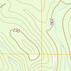
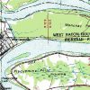
2015 USGS Topo Maps added November 8, 2016
Atlas has added Louisiana’s 2015 “topos” to its collection of USGS topographic maps. The 2015 maps are accessible through a new map downloader and FTP site. The maps are in PDF format, as provided to the Cartographic Information Center (Map Library) at Louisiana State University, who provided the dataset to Atlas. See the dataset details page for […]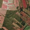
1998 DOQQ imagery added August 7, 2016
Another addition to the DOQQ series: the 1998 dataset has been posted with a map downloader and FTP access. The quarter-quad MrSID files will be compiled into a mosaic so a basemap can be offered on Atlas as a web service. That service will be online soon. For now, the downloader shows an Esri basemap […]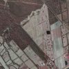
2004 DOQQ imagery added August 4, 2016
The DOQQ 2004 dataset has been copied here to the new Atlas site. The images cover the state at 1-meter resolution in color infrared, although several quarter-quads appear to be missing in the dataset taken from the old Atlas site. The other DOQQ datasets available on the old Atlas (1998 and 2005) are next in line […]
GOHSEP 2010 basemap optimized July 5, 2016
The performance of the GOHSEP 2010 downloader and web service has been improved significantly–10 times faster in some cases on the downloader page. The service was cached down to the 1:2,000-scale zoom level, and on the downloader page, the Leaflet map was modified to use the coordinate reference system of the data instead of projecting on the […]
GOHSEP 2010 dataset added June 18, 2016
The GOHSEP 2010 imagery has been added to the new Atlas site as downloads and as a web service basemap. The imagery was provided to Atlas as individual parish mosaics with the boundary images clipped to exclude parts of the quad not contained with the parish boundary. Therefore, to get a complete image of a quad […]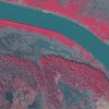
2008 DOQQ coastal imagery added June 16, 2016
A collection of MrSid files not available on the old Atlas site has been added here: the 2008 DOQQ coastal imagery dataset. The images cover parts of Louisiana, Mississippi, and Alabama at 1-meter resolution in color infrared and true color. Both products are available for download and as web services. See the map or dataset […]
USGS digital raster graphics added June 14, 2016
Atlas’ collection of scanned USGS topographic maps, or digital raster graphics (DRG), are now accessible through a new map downloader and FTP site. The historical DRGs are mostly from 1998 and are in TIFF format. The collection includes a set of “updated” sheets for 74 quads around the state. The scans are a little higher quality and […]
Statewide lidar dataset added June 11, 2016
The elevation dataset created by the Louisiana Statewide Lidar Project, begun in 2000 and carried out over a few years, has been posted to the new Atlas site. The project produced contours and DEM imagery derived from the lidar point cloud data. All are available for download from the dataset details page. Here’s […]