
Statewide lidar dataset added
June 11, 2016
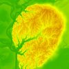 The elevation dataset created by the Louisiana Statewide Lidar Project, begun in 2000 and carried out over a few years, has been posted to the new Atlas site. The project produced contours and DEM imagery derived from the lidar point cloud data. All are available for download from the dataset details page.
Here’s a summary of what’s available:
- Digital Elevation Model (DEM, 5 meters)
- Contours (shapefile, 2 feet)
- Breaklines (shapefile)
- Point cloud (edited and raw, point spacing of 3-4 meters)
See the metadata packaged with each quarter-quad product for the acquisition date and other details. This dataset has been on Atlas for many years and the downloads available now on the new site are still the same files. There is some additional data on the National Map and Earth Explorer.