
Upcoming changes for Atlas
May 19, 2016
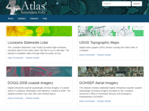 The Atlas website currently at atlas.lsu.edu will have parts updated over the coming months to fix the site’s compatibility issues. The interactive maps have had problems with Java as the applet has aged and as that type of plugin has been phased out by browsers.
The maps for downloading lidar and USGS digital raster graphics will be replaced first, and a new aerial imagery map will be added (2010 GOHSEP 6-inch statewide imagery). The DOQQ downloaders are slated for replacement, too. The current “downloaders” on atlas.lsu.edu require Java and have become increasingly difficult to use with modern browsers. They are being replaced by HTML5 web maps that do not require plugins and work across browsers and platforms.
Alternative methods for downloading data are being setup as well. The lidar and DRG datasets will be available via FTP, and some vector and raster data will be published as web services (WMS and ArcGIS REST).
Dataset additions and other site announcements will be posted here at the updates blog.
The website updates are part of a project creating a platform for hosting and sharing GIS datasets that would otherwise be inaccessible (those stored on private servers and USB drives, for example). Atlas is a key component in a data distribution system planned by the Geography and Anthropology Department at Louisiana State University. The hardware supporting the project was funded with a grant from the Louisiana Board of Regents.