
USGS digital raster graphics added
June 14, 2016
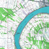 Atlas’ collection of scanned USGS topographic maps, or digital raster graphics (DRG), are now accessible through a new map downloader and FTP site. The historical DRGs are mostly from 1998 and are in TIFF format.
The collection includes a set of “updated” sheets for 74 quads around the state. The scans are a little higher quality and include the DRG collar.
These topographic maps are provided as a historical reference and were made available early in the development of the new website because they continue to be downloaded frequently on the old Atlas site.
For a current USGS topographic basemap, see the “USA Topo Maps” basemap in ArcGIS.