
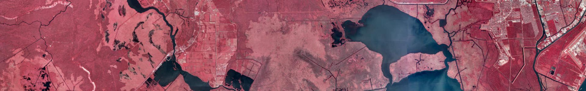
Digital orthophoto quarter quadrangle (DOQQ) color infrared imagery of coastal Louisiana taken in 2005 at 1-meter resolution.
Metadata
Collection date: 2005
Resolution: 1 meter
Coverage: Coastal Louisiana
Downloadable data format: MrSid
Dataset readme.txt
Notes
This dataset contains digital orthophotographs for USGS 1:24,000 quarter quadrangles (DOQQ) taken in 2005. The 24-bit RGB images have been compressed 20:1 in MrSid format.
Processing
David Gisclair of the Louisiana Oil Spill Coordinators Office supplied the LSU CADGIS Research Laboratory with uncompressed TIF files containing the images and metadata in XML form.
DeWitt Braud of the LSU Coastal Studies Institute and his staff converted the TIF files into JPEG 2000 formatted files with accompanying world files. The conversion created overviews or view pyramids for the images. During the conversion process, the images were compressed with a 20:1 compression ratio. As a result, the image files are about 7 to 8 megabytes in size.
Due to problems with older software not being able to read JPEG2000 formatted image files, the TIF files were converted to MrSid format with a 1:20 compression ratio. This Winzip archive contains the MrSid image and its world file and not the JPEG2000 file.
The staff of the LSU CADGIS Research Laboratory renamed the newly created files to follow a naming convention similar to that of the DOQQ 2004 files. CADGIS also added a Geomedia csf file and an ESRI prj file to document projection. Then, the files were placed into a Winzip archive for downloading.
Coordinate Systems
The image file is projected to the UTM 15 NAD 83 coordinate system. The X, Y coordinates are UTM zone 15 North meters with a datum of North American Datum 1983. Each cell of the image is 1 meter by 1 meter.
Note that images that fall within UTM zone 16 have been reprojected so that their coordinate system is UTM zone 15. This reprojection allows for all images to be displayed as UTM zone 15.
Archive Contents
Each zip archive file downloaded from Atlas should have at least the following files as listed below.
The cdddddnn_xxs_20 in the file names represents:
- c – color images
- ddddd – the 1 degree x 1 degree block as designated by USGS
- nn – the 7.5′ quadrangle within the block ddddd. nn ranges from 01 to 64
- xx – the quadrant of the 7.5′ quadrangle. xx is one of NE, NW, SE, or SW
- s – MrSid image format
- _20 – the image has been compressed 20:1
The files included in each zip:
1) cdddddnn_xxs_20.sdw – An ASCII world file containing coordinate information for the corresponding .sid file.
2) cdddddnn_xxs_20.sid – A MrSid formatted image file containing the DOQQ image.
3) readme.txt – You are reading it!
4) utm15nad83.csf – A Geomedia coordinate system file.
5) utm15nad83.prj – An ArcGIS projection file.